Introduction to Navigating the British Moors
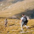
The British moorlands are a true treasure for outdoor enthusiasts, offering sweeping vistas of heather-clad hills, mysterious peat bogs, and windswept ridges that stretch as far as the eye can see. From the wild expanses of Dartmoor in Devon to the rugged beauty of the Yorkshire Dales and the hauntingly beautiful North York Moors, these unique landscapes are deeply woven into the fabric of British culture. Whether you’re enjoying a leisurely walk with your family, rambling with friends, or tackling a challenging fell run, the moors promise adventure and tranquillity alike. However, their open terrain and changeable weather can quickly turn an enjoyable day out into a tricky situation if you lose your way. This is why understanding accurate navigation—using tools like bearings and grid references—is absolutely essential when exploring these remarkable places. Not only does it ensure your safety and confidence on the hills, but it also allows you to fully appreciate the freedom and beauty that Britain’s moorlands have to offer.
2. What are Bearings and Grid References?
If you’ve ever wandered across the British moors or countryside, you’ll know just how easy it is to lose your bearings—quite literally! Two vital tools every rambler should be familiar with are compass bearings and Ordnance Survey grid references. These aren’t just for seasoned hikers; even a family stroll can benefit from understanding these basics, especially when the weather turns or paths become less distinct.
Compass Bearings: The Basics
A bearing is simply the direction from one point to another, measured in degrees from North (which is always 0° or 360°). Using a compass, you can set a bearing to make sure you’re heading exactly where you intend to go, rather than wandering off course. Here’s a quick look at how bearings work:
| Direction | Degrees |
|---|---|
| North | 0° / 360° |
| East | 90° |
| South | 180° |
| West | 270° |
This simple system keeps things straightforward even if visibility drops on the moor or you’re faced with a maze of sheep tracks.
Ordnance Survey Grid References: Pinpointing Your Location
The Ordnance Survey (OS) maps are a staple of British outdoor adventures. Grid references let you pinpoint your exact location on these maps using a combination of letters and numbers. This system breaks down the map into squares, making it easier to communicate locations quickly and accurately.
| Type of Reference | Format Example |
|---|---|
| Four-figure (general area) | SE1234 |
| Six-figure (precise spot) | SE123456 |
This is particularly handy if you need to let someone know where you are—perhaps for meeting up with friends or, more importantly, in an emergency situation.
Why Are They Essential in the UK Countryside?
The British landscape can be deceptive: what looks like a gentle hill from afar may hide deep gullies, bogs or sudden changes in weather. With reliable bearings and grid references, walkers avoid getting lost and can navigate safely back to their starting point or next destination. Whether you’re exploring Dartmoor, the Lake District or the Yorkshire Dales, mastering these tools isn’t just sensible—it’s essential for safe and enjoyable adventures with family and friends.
3. Essential Tools for British Navigation
Navigating the British moors is both a cherished tradition and a practical challenge, requiring reliable tools to ensure accuracy and safety. Over the years, several key items have become staples in the rucksacks of walkers, families, and seasoned ramblers alike.
Ordnance Survey (OS) Maps
The gold standard for navigation in the UK, Ordnance Survey maps provide detailed information about the landscape, including contour lines, footpaths, landmarks, and even walls and fences. These maps are available in various scales, with the Explorer (1:25,000) and Landranger (1:50,000) series being particularly popular for moorland adventures. The clarity and detail of OS maps make them indispensable for planning routes or identifying your position amidst the vast open terrain.
Silva-Style Compasses
While there are many compass brands available, Silva compasses have gained a loyal following among British walkers due to their reliability and ease of use. A baseplate compass with a rotating bezel is ideal for taking accurate bearings and working seamlessly with grid references on OS maps. Even when digital devices falter in poor weather or remote areas, a trusty compass will keep you on track—making it an essential part of any moorland toolkit.
Popular Digital Apps
Modern technology has brought navigation into the palm of our hands. Apps such as OS Maps, ViewRanger, and Komoot are widely used across the UK. These apps often feature downloadable offline maps, GPS tracking, and route planning—ideal for those who want extra reassurance or wish to share their adventures with friends and family. However, its always wise to carry physical backups since phone batteries can drain quickly on chilly moors.
Finding What Works for Your Family
Whether you’re planning a family stroll through the Peak District or tackling Dartmoor’s wild expanses, combining traditional tools like paper maps and compasses with digital aids offers both confidence and flexibility. Teaching children to read a map or take a bearing can turn an ordinary walk into an engaging adventure—and ensures everyone knows how to get home safely if technology lets you down.
4. Taking a Bearing: Step-by-Step for the British Outdoors
Navigating the British moors can feel like a grand adventure, especially when you’re equipped with the right tools and know-how. Taking an accurate bearing with a compass is easier than you might think, and it’s a skill that the whole family can master together—rain or shine! Here’s a simple, family-friendly guide to help you find your way, even when the clouds roll in and the wind picks up.
Step-by-Step Guide to Taking a Bearing
- Identify Your Landmark: Choose a visible feature on the landscape, such as a tor, tree, or distinctive hilltop.
- Hold Your Compass Flat: Keep your compass level in your palm so the needle can move freely. Make sure everyone has their compasses facing the same direction—pointing ahead of you.
- Point the Direction-of-Travel Arrow: Aim this arrow directly at your chosen landmark.
- Rotate the Compass Housing: Turn the housing until the orienting lines match up with north on the map (if you have it handy) or so that ‘N’ on your compass aligns with the red end of the needle.
- Read Your Bearing: Look at where the direction-of-travel arrow meets the numbers on the compass housing. This number is your bearing in degrees.
- Adjust for Magnetic Variation: In Britain, magnetic variation is generally small but worth checking. Add or subtract as needed—your Ordnance Survey map will usually indicate how much adjustment is required.
Family Tips for Navigating British Weather
| Weather Condition | Top Tip |
|---|---|
| Mist or Fog | Keep group close together and recheck bearings more often. Use whistle signals if visibility drops suddenly. |
| Rain | Keep maps and compasses dry using clear plastic pouches. Wipe compass face regularly for clear readings. |
| Windy Days | Shelter behind a wall or shrub while taking a bearing to stop hands from shaking and affecting accuracy. |
| Bright Sunlight | Avoid glare by shading your compass with your hand or cap. Double-check bearings to avoid mistakes caused by reflections. |
Keeping It Fun and Safe for All Ages
- Let each family member take turns using the compass—it builds confidence and keeps kids engaged.
- If you get stuck, pause for a snack break and review your steps together—teamwork makes navigation easier!
- Praise kids for good decisions and encourage questions about what they see around them; it’s all part of learning outdoors.
Quick Reference: Compass Steps for Young Explorers
- L: Look at where you want to go.
- A: Aim your compass at it.
- M: Match north on your compass with north on your map or needle.
- P: Point and go—the MAP method!
Remember:
The British countryside is unpredictable but rewarding. With these steps, even families new to navigation can enjoy exploring safely—and confidently—no matter what weather comes rolling over those beautiful moors!
5. Using Grid References to Pinpoint Your Location
If you’re out rambling on the British moors, knowing how to read and communicate grid references is a must for safe and accurate navigation. Ordnance Survey (OS) maps use a straightforward system that helps walkers, families, and adventurers alike pinpoint exact locations—even in wide open spaces where landmarks can be few and far between.
How Grid References Work
The OS map grid is made up of a series of vertical (eastings) and horizontal (northings) lines, creating a network of squares across the landscape. Each line is numbered, helping you find your way by matching these numbers to the map edges. A grid reference tells you precisely which square—or more accurately, which part of a square—you are in.
The Six-Figure Grid Reference System
The British convention for grid references typically uses six figures, providing a location accurate to within 100 metres. Here’s how it works:
- Step 1: Find the Eastings – First, look along the bottom or top edge of your OS map to find the eastings number just before your location. This gives you the first two digits. Then, estimate how many tenths across the square your point lies, adding this as a third digit.
- Step 2: Find the Northings – Next, look up the side of your map to find the northings number just below your location. Again, this gives you two digits. Estimate how many tenths up the square you are for the sixth digit.
Example: Reading a Six-Figure Grid Reference
If you locate a spot that is just past easting 25 and northing 42, about seven-tenths across and four-tenths up the respective squares, your grid reference would be 257424. Always remember: “Along the corridor and up the stairs”—that’s eastings first, then northings!
Communicating Grid References Clearly
When sharing your position with friends or emergency services on the moors, always give the two-letter prefix from your map (for example, SE or NY), followed by your six-figure reference—like SE 257 424. Double-check each number before passing it on; clarity is key when safety depends on accuracy.
Mastering this simple system ensures everyone in your group stays on track and offers peace of mind if help is ever needed. So next time you’re out exploring Britain’s wild places, make sure grid references are second nature—it’s an essential tool for every family-friendly adventure!
6. Safety and Common Pitfalls on the Moors
Venturing onto the British moors is a rewarding experience, but it comes with its own set of challenges. Even with sound knowledge of bearings and grid references, it’s easy to make mistakes if you’re not mindful of local conditions and best practices. Here’s some friendly, practical advice to help you navigate safely and confidently.
Let Someone Know Your Plans
Before heading out, always let a trusted friend or family member know your intended route and estimated return time. This simple habit can make all the difference in an emergency. The British weather and terrain can be unpredictable—even experienced walkers can find themselves in tricky situations.
Check the Local Forecast
The moors are notorious for rapidly changing weather. A sunny morning can quickly turn into a misty, drizzly afternoon, making navigation much harder. Always check the Met Office forecast before setting off, and be prepared to adjust your plans if conditions look dicey. Take extra care in winter, as short daylight hours and fog can increase risks.
Stay on Rights of Way
Stick to marked footpaths and bridleways wherever possible. Not only does this help conserve delicate moorland habitats, but it also reduces your chances of getting lost or wandering onto private land—something that’s especially important in areas like Dartmoor or Yorkshire, where access rights vary.
Avoiding Common Mistakes
- Overreliance on Technology: GPS devices and smartphones are handy, but batteries die and signal can vanish on the moors. Always carry a paper map and compass as backup.
- Miscalculating Distance: It’s easy to underestimate how far you’ve walked when visibility drops or terrain gets tough. Regularly check your position using grid references, and don’t be afraid to turn back if you’re unsure.
- Poor Preparation: Pack enough water, snacks, and layers—even for a short walk. Waterproofs are essential, as sudden showers are part and parcel of British moorland walks.
Final Thoughts
Respecting the unique character of Britain’s moors means staying alert, planning ahead, and knowing your limits. By following these safety tips and being aware of common pitfalls, you’ll ensure that your adventures remain enjoyable—and safe—for everyone involved.
7. Practising Your Skills: Family-Friendly Walks on the Moors
Exploring the British moors is a wonderful way for families to bond while developing navigation skills that will last a lifetime. The moorlands offer gentle gradients, open landscapes, and well-marked trails—ideal conditions for practising bearings and grid references in a safe environment. Here are some suggestions for relaxed routes and creative ways to make navigation engaging for children.
Gentle Moorland Routes for Beginners
If you’re just starting out with map and compass work, consider heading to spots like Dartmoor’s Haytor area, where circular walks keep you within sight of familiar landmarks. The North York Moors’ Sutton Bank offers accessible paths with panoramic views, perfect for short outings and clear navigational checkpoints. In the Peak District, the Longshaw Estate features family-friendly trails with plenty of features—like stone walls, ancient trees, and streams—that are easy to locate on an Ordnance Survey map.
Engaging Children in Navigation
Transforming navigation into a game can spark children’s curiosity and enthusiasm. Try these ideas:
- Navigation Treasure Hunt: Mark simple grid references on your map and let children find them, rewarding each successful location with a treat or a story about local history.
- Bearing Races: Challenge older children to take turns using the compass to set bearings between visible landmarks—such as standing stones or tors—and see who can plot the most accurate route.
- Create a Nature Log: Encourage younger ones to spot features from the map (like streams or boundary stones), drawing or photographing what they find along the way.
Tips for a Fun & Safe Experience
Always check the weather before setting out and bring enough snacks and water for everyone. Use large-scale Ordnance Survey Explorer maps (1:25,000) for clarity, and don’t forget layers—even in summer, moorland weather can change rapidly. Most importantly, celebrate small successes: even finding your first grid reference together is cause for a congratulatory picnic!
Navigating as a family on Britain’s moors isn’t just about learning to use tools—it’s about building confidence and creating happy memories outdoors. With a little planning and a sense of adventure, everyone can enjoy mastering bearings and grid references in some of the UK’s most beautiful wild spaces.