Introduction to the Yorkshire Three Peaks Challenge
Nestled in the heart of the Yorkshire Dales National Park, the Yorkshire Three Peaks Challenge is a rite of passage for outdoor enthusiasts across the UK. This demanding yet rewarding trek takes participants on a circular route over the iconic summits of Pen-y-ghent, Whernside, and Ingleborough. Covering approximately 24 miles (38.6 km) with a total ascent of around 1,600 metres, challengers aim to complete the circuit in under 12 hours—a true test of endurance and determination. The event’s location amidst rolling moorland, dramatic limestone pavements, and quintessentially British countryside scenery adds to its enduring appeal. Within the UK outdoor community, the Yorkshire Three Peaks Challenge holds a special place as both an introduction to long-distance hiking and a beloved annual tradition for seasoned walkers. It not only showcases the natural beauty of Yorkshire but also fosters camaraderie and respect among those who take on its rugged trails.
2. Essential Preparation and Planning
Tackling the Yorkshire Three Peaks Challenge is no small feat, and thorough preparation is crucial for a safe and enjoyable experience. Below, you’ll find practical advice covering training, equipment, weather considerations, and local transport options—everything a participant needs to know before setting off.
Training for the Challenge
The route covers approximately 24 miles (39km) with over 1,500 metres of ascent, making physical readiness essential. Start a walking or hiking regimen at least two months in advance. Include varied terrains and elevation in your training walks; aim for regular hikes that increase in distance and difficulty. Don’t forget to test your stamina with back-to-back long walks over weekends. If possible, train on similar terrain to the Dales to prepare your muscles for the challenge ahead.
Essential Equipment Checklist
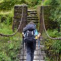
Your kit can make or break the day. Weather conditions in the Yorkshire Dales are famously unpredictable, so being prepared is non-negotiable. Refer to the table below for essentials:
| Item | Purpose/Tip |
|---|---|
| Sturdy walking boots | Waterproof, well-broken-in boots are vital for rocky and boggy sections. |
| Layered clothing | Base layers, insulating mid-layers, waterproof jacket & trousers—adapt for changing weather. |
| Backpack (20-30L) | Sufficient size for food, water, and spare layers without being cumbersome. |
| Navigation tools | Map (OS Explorer OL2), compass, and/or GPS device; don’t rely solely on mobile phone signal. |
| Food & water | High-energy snacks and at least 2 litres of water per person. |
| First aid kit | Include blister plasters and pain relief. |
| Head torch | Essential if you’re not confident you’ll finish before dusk. |
| Sunscreen & hat | Protection against sun exposure even on cloudy days. |
| Emergency whistle & foil blanket | Sensible additions for safety in remote areas. |
Weather Considerations
The Dales weather changes rapidly; sunny mornings can turn into foggy afternoons or sudden downpours. Always check the local Met Office forecast before your walk. Dress in layers so you can adjust quickly as needed. Avoid setting off in extreme weather conditions—especially high winds or heavy rain—as visibility on summits like Ingleborough or Pen-y-ghent can drop rapidly.
Local Transport Options
The start point at Horton-in-Ribblesdale is accessible by train from Leeds or Lancaster via the Settle-Carlisle line—a scenic and popular choice among walkers keen to avoid parking headaches. There’s limited parking in Horton itself; arriving early is advised if driving. For those staying locally, several community-run taxi services operate between villages such as Ribblehead and Chapel-le-Dale, providing useful fallback options if you need to cut your walk short or return to your base after completing the challenge.
Transport Summary Table
| Option | Details/Advice |
|---|---|
| Train (Settle-Carlisle Line) | Direct access to Horton-in-Ribblesdale; ideal for avoiding car parking issues. |
| Car Parking | Available but limited; arrive early or consider car sharing with fellow participants. |
| Local Taxi/Minibus | A good option for groups or as a backup plan after finishing the walk. |
| Buses (seasonal) | A few services connect larger towns with nearby villages—check current timetables before planning your journey. |
Final Thoughts on Preparation
A successful Yorkshire Three Peaks Challenge hinges on solid planning: invest time in training, assemble appropriate gear, monitor the weather forecast closely, and sort your travel logistics early. With these boxes ticked, you’ll be ready to enjoy everything this iconic British adventure has to offer.
![]()
3. The Three Peaks: Pen-y-Ghent, Whernside, and Ingleborough
The Yorkshire Three Peaks Challenge is defined by its trio of iconic summits—Pen-y-Ghent, Whernside, and Ingleborough. Each peak offers a distinct walking experience, presenting its own set of distances, terrains, and local characteristics. Here’s a detailed look at each one to help you prepare for what lies ahead.
Pen-y-Ghent
Distance & Terrain
Standing at 694 metres (2,277 ft), Pen-y-Ghent is often the first peak tackled in the challenge. The ascent begins gently but soon turns into a steep climb with some rocky scrambles near the summit. The path can be boggy after rain, so sturdy boots are essential.
Unique Features
Pen-y-Ghent’s distinctive profile, resembling a lion’s head, is visible from miles around. Its summit offers panoramic views across the Dales and beyond on a clear day. The gritstone and limestone scenery is typical of Yorkshire’s rugged beauty.
Points of Interest
The route passes the historic Hull Pot—a collapsed cavern that becomes a dramatic waterfall in wet weather—and sections of ancient dry-stone walls. Wildlife enthusiasts may spot curlews or lapwings in the surrounding moorland.
Whernside
Distance & Terrain
At 736 metres (2,415 ft), Whernside claims the title of the highest point in Yorkshire. The approach includes a long but gradual ascent along grassy tracks and stony paths, making it less technical than Pen-y-Ghent but still physically demanding.
Unique Features
The summit ridge provides an extensive vista over Morecambe Bay and the Lake District fells. Whernside’s gentle slopes can be deceptive; wind exposure and boggy patches are common challenges here.
Points of Interest
The famous Ribblehead Viaduct—a marvel of Victorian engineering—lies nearby, and walkers often pause for photos before climbing Whernside itself. The railway line and open expanses add to the sense of remoteness.
Ingleborough
Distance & Terrain
Rising to 723 metres (2,372 ft), Ingleborough is typically the final summit in the challenge. The approach features limestone pavements, short steep scrambles, and broad plateaus. Underfoot conditions can vary from loose stone to slippery grass.
Unique Features
The flat-topped summit is marked by ancient earthworks and offers commanding views in all directions. Ingleborough is also known for its mysterious caves and potholes scattered around its base.
Points of Interest
Penyghent Gill, Gaping Gill cave system, and the remains of an Iron Age fort near the summit are highlights for those interested in geology and history alike. The descent towards Horton-in-Ribblesdale marks the closing stretch of the challenge for many participants.
4. Popular Routes and Navigation Tips
The Yorkshire Three Peaks Challenge is typically tackled via the classic circular route, which allows walkers to summit Pen-y-ghent, Whernside, and Ingleborough in a continuous loop. This tried-and-tested path is favoured for its logical progression and well-trodden tracks, making it the standard for most challengers aiming to complete all three peaks within twelve hours.
A Guide to the Classic Circular Route
Most participants opt for an anti-clockwise direction, starting and finishing at Horton-in-Ribblesdale. This order helps distribute the climbs more evenly and allows for easier access to amenities at the start and end of the challenge. The route covers approximately 24 miles (38.6 km) with a cumulative ascent of around 1,585 metres.
Common Starting Points
| Starting Point | Facilities | Advantages |
|---|---|---|
| Horton-in-Ribblesdale | Café, public toilets, parking, train station | Main hub; official timing point; easy logistics |
| Ribblehead Viaduct | Limited parking, scenic spot | Good for those arriving by car from north; picturesque backdrop |
| Chapel-le-Dale | Pubs, small car park | Quieter; useful for alternative approaches or shorter circuits |
Navigation Challenges on the Peaks
While much of the route is signposted, Yorkshire weather can be unpredictable and visibility on the fells may drop quickly. Key navigation points to watch out for include:
- Penyghent Summit Plateau: Can be misty; keep to the flagged path.
- Boggy Sections between Whernside and Ingleborough: Especially tricky after rain; stick to visible trails where possible.
- Ingleborough Descent: Steep and rocky; take care with footing in wet conditions.
Recommended Maps and Apps
| Resource | Description | Where to Get It |
|---|---|---|
| OS Explorer OL2 Map | Dales area map covering all three peaks in detail. | Outdoor shops, online retailers, local newsagents |
| OS Maps App | Digital mapping tool with GPS tracking features. | App Store/Google Play; subscription recommended for offline use |
| Komoot/AllTrails Apps | User-friendly apps with downloadable routes and community reviews. | App Store/Google Play; free and paid versions available |
| Pennine Way Guidebook Sections | Covers segments relevant to Three Peaks challenge walkers. | Bookshops, libraries, local tourist centres |
Tackling the Three Peaks safely relies on being prepared with reliable maps and navigation tools. Always check weather forecasts before setting off and let someone know your planned route. Local walking groups or challenge organisers can also offer invaluable advice based on current trail conditions.
5. Traditions, Local Customs, and Community Spirit
The Yorkshire Three Peaks Challenge is much more than a test of endurance; it’s deeply rooted in local traditions and customs that reflect the character of the region. At the heart of this challenge is a unique sense of community spirit, which you’ll feel from the moment you set foot in the Dales.
Local Rituals and Camaraderie
Before setting off, it’s not uncommon for groups to gather at Horton-in-Ribblesdale, sharing a hearty breakfast or a strong cup of Yorkshire tea. This pre-walk ritual is as much about fuelling up as it is about bonding with fellow walkers—strangers soon become companions on the trail. Along the route, friendly greetings of “Ey up!” or “How’s tha doing?” are exchanged, reinforcing the welcoming nature typical of Yorkshire folk.
Fundraising Practices
The Challenge is often used as a platform for charity fundraising, with local teams and individuals raising money for causes close to their hearts. You’ll spot hand-painted signs and donation buckets at starting points, and many participants wear T-shirts emblazoned with charity logos. Fundraising isn’t just an afterthought—it’s woven into the event’s fabric, with local businesses and pubs frequently sponsoring teams or matching donations.
Pub Stops and Social Traditions
No description of Yorkshire tradition would be complete without mentioning its pubs. Iconic establishments like The Crown in Horton-in-Ribblesdale or The Golden Lion in Settle serve as gathering spots before, during, or after the walk. Popping in for a pint of locally brewed ale or a plate of pie and peas is almost considered part of the challenge itself. These stops offer a chance to rest weary legs, share stories from the route, and enjoy genuine northern hospitality.
The Unique Spirit of Yorkshire Events
What truly sets the Yorkshire Three Peaks Challenge apart is its atmosphere of mutual support. Whether you’re a first-timer or a seasoned walker, you’ll find encouragement at every stile and summit. Locals often set up refreshment stations offering water, flapjack, or even homemade cake—all given freely to keep spirits high. It’s this camaraderie and sense of shared achievement that linger long after the last peak has been conquered.
6. Environmental Considerations and Responsible Walking
The Yorkshire Three Peaks Challenge is a rewarding adventure, but it also comes with a responsibility to protect the stunning natural landscape of the Yorkshire Dales. As walkers traverse Pen-y-ghent, Whernside, and Ingleborough, adhering to environmental best practices ensures these cherished peaks remain unspoilt for future generations.
Leave No Trace Principles
Upholding the Leave No Trace ethos is crucial on this popular route. Simple acts like packing out all litter—including biodegradable items—and sticking to established paths prevent unnecessary damage to fragile moorland and rare limestone pavement habitats. Avoid picking wildflowers or disturbing wildlife; even seemingly minor actions can have ripple effects on local ecosystems.
Respecting Farmland and Livestock
The Three Peaks route crosses active farmland, often shared with sheep and cattle. Respecting farmers’ livelihoods means closing gates behind you, keeping dogs under close control (or on leads during lambing season), and never disturbing livestock. If you encounter farm vehicles or work in progress, step aside courteously and allow local operations to continue unhindered.
The Role of the Yorkshire Dales Community in Conservation
Local residents, businesses, and volunteer rangers play an essential part in maintaining both the beauty and accessibility of these trails. Many participate in regular path repairs, litter picks, and educational programmes promoting sustainable walking. Supporting local cafés, shops, or accommodation not only adds to your experience but also strengthens the community’s capacity to care for its environment.
By embracing respectful walking habits and supporting conservation efforts led by the Yorkshire Dales community, participants ensure the Three Peaks Challenge remains an uplifting experience—for both visitors and those who call this landscape home.
7. After the Challenge: What to Do and Where to Go
Completing the Yorkshire Three Peaks Challenge is no small feat, and it deserves a proper celebration. Many participants choose to mark their achievement with a hearty meal at one of the traditional pubs in Horton-in-Ribblesdale or nearby villages such as Ribblehead and Chapel-le-Dale. Local favourites like the Crown Hotel or the Station Inn offer classic Yorkshire fare—think pie and mash, real ale, and a welcoming atmosphere where you can swap stories with fellow walkers.
Suggestions for Celebrating Your Success
Gathering your group for a celebratory drink is almost a rite of passage after the challenge. If you’re seeking something unique, try a slice of Yorkshire parkin cake or some Wensleydale cheese from a local deli. For those who prefer something quieter, a post-walk picnic by the River Ribble provides a relaxing way to wind down and reflect on your accomplishment.
Nearby Attractions Worth Exploring
The Yorkshire Dales National Park offers plenty more to see beyond the peaks themselves. Consider visiting Malham Cove, an impressive limestone amphitheatre, or White Scar Cave for an underground adventure. The Settle-Carlisle Railway is also famed for its scenic views—perfect for unwinding while enjoying the landscape you’ve just conquered on foot.
Supporting Local Businesses and Charities
Your visit to this region is also an opportunity to give back to the community that hosts this iconic challenge. Many local cafés, guesthouses, and shops rely on hikers’ custom; purchasing souvenirs or locally produced goods helps sustain these small enterprises. Additionally, several local charities benefit directly from challenge events—consider making a donation to organisations involved in trail maintenance or rural community support. By choosing local guides, eating at independent eateries, and respecting countryside traditions, you help preserve both the landscape and its culture for future adventurers.